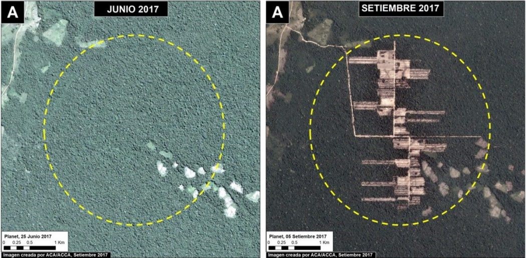
Deforestation just north of the Imiria Conservation Area in Ucayali, which took place between June and September 2017.
Analysis of satellite imagery has unearthed evidence of
rapid, industrial-style forest clearance in an area of the Peruvian Amazon where six farmers were
recently assassinated.
The Monitoring of the Andean Amazon Project (MAAP)
identified deforestation inside protected areas in Ucayali province, and
indications of roads created to facilitate much larger clearances.
In September, six members of a local agricultural
association were tied up and shot near one of the cleared areas. The attack
stemmed from a dispute over the ownership of agricultural land in the area,
with evidence pointing to the involvement of land traffickers.
MAAP analysts said it was “very unlikely” that the recent
clearances were the work of smallholders. They occurred rapidly, requiring
expensive machinery, and in a manner that suggests a long-term plan to develop
the site.
“Where you can see straight access roads, you are probably
tracing the beginnings of an agro-industrial project,” the sociologist Juan
Luis Dammert told Peruvian newspaper La Republica,
describing the clearance pattern apparent in two of the cleared areas.
MAAP identified the destruction of 360 hectares of primary
rainforest in the provinces of Ucayali and Loreto, both of which have
experienced extensive illegal
clearances for palm
oil and cocoa plantations.
At least 76 hectares of the most recent deforestation is
illegal, the analysis states, as it took place in an area of Permanent
Production Forest.


